
Check out my exclusive IELTS EBooks here on Patreon.
The Complete Guide to IELTS Cambridge 17
The Complete Guide to IELTS Cambridge 16
The Complete Guide to IELTS Cambridge 15
The Complete Guide to IELTS Cambridge 14
The Complete Guide to IELTS Cambridge 13
IELTS Cambridge 17 Essay: Map of an Industrial Area (Norbiton)
The maps illustrate an industrial area in Norbiton in the present day compared with plans for future development of the site.
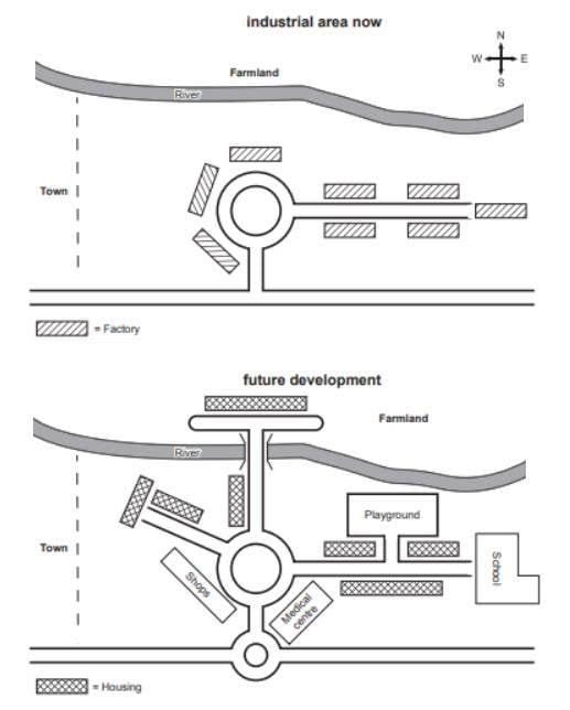
The above maps detail Norbiton in the present day and plans for future development. Looking from an overall perspective, it is readily apparent that the town will become less industrial and more residential with the construction of facilities for housing, education, shopping, and medical care. This development will occur primarily to the west and north with only a small patch of farmland remaining undisturbed.
In the current town, there is a central roundabout surrounded by factories and a road running from west to east out of Norbiton. In the future, the roundabout will remain but the factories around it will become shops, new housing will line a northwestern road, and there will be a new hospital built to the southeast. The original road going to the east will also now have housing on either side along with a large playground to the north and a school at the easternmost border of the town.
Outside the center of the town, there are also plans for a smaller roundabout in the south which will bisect an existing street. In the north, there will be a bridge over the river and the farmland to the north will be partly replaced with housing, though not to the east where no alterations will be made.
Analysis
1. The above maps detail Norbiton in the present day and plans for future development. 2. Looking from an overall perspective, it is readily apparent that the town will become less industrial and more residential with the construction of facilities for housing, education, shopping, and medical care. 3. This development will occur primarily to the west and north with only a small patch of farmland remaining undisturbed.
- Paraphrase what the map shows.
- Write a clear overview summarising the differences.
- You might need another sentence for your overview.
1. In the current town, there is a central roundabout surrounded by factories and a road running from west to east out of Norbiton. 2. In the future, the roundabout will remain but the factories around it will become shops, new housing will line a northwestern road, and there will be a new hospital built to the southeast. 3. The original road going to the east will also now have housing on either side along with a large playground to the north and a school at the easternmost border of the town.
- Begin writing about the first part of the map.
- Make sure you compare as much as possible.
- Don’t leave anything out!
1. Outside the center of the town, there are also plans for a smaller roundabout in the south which will bisect an existing street. 2. In the north, there will be a bridge over the river and the farmland to the north will be partly replaced with housing, though not to the east where no alterations will be made.
- Write about the final, other parts of the map – include everything!
- Mention anything that has not changed on the map too.
Vocabulary
The above maps detail Norbiton in the present day and plans for future development. Looking from an overall perspective, it is readily apparent that the town will become less industrial and more residential with the construction of facilities for housing, education, shopping, and medical care. This development will occur primarily to the west and north with only a small patch of farmland remaining undisturbed.
In the current town, there is a central roundabout surrounded by factories and a road running from west to east out of Norbiton. In the future, the roundabout will remain but the factories around it will become shops, new housing will line a northwestern road, and there will be a new hospital built to the southeast. The original road going to the east will also now have housing on either side along with a large playground to the north and a school at the easternmost border of the town.
Outside the center of the town, there are also plans for a smaller roundabout in the south which will bisect an existing street. In the north, there will be a bridge over the river and the farmland to the north will be partly replaced with housing, though not to the east where no alterations will be made.
Answers
For extra practice, write an antonym (opposite word) on a piece of paper to help you remember the new vocabulary:
above over
detail show
in the present day today
future development plans for later
Looking from an overall perspective, it is readily apparent that overall
less industrial not as many factories and businesses
more residential more people living there in homes
construction building of
facilities places
housing places to live
education schools
shopping places to shop
medical care hospitals
occur primarily happens mostly
to the west and north in the right and top part
small patch little piece
farmland agricultural land
remaining undisturbed staying unchanged
In the current town where it is now
central roundabout rotary in the middle
surrounded by on all sides
running from west to east out of going from left to right
line are alongside of
northwestern top left
southeast. bottom right
original how it was
on either side on both sides of
along with and
playground place for kids to play
easternmost border to the east, the furthest point
outside past
bisect cut in half
existing is there now
bridge goes over rivers
partly replaced somewhat taking the place of
though however
alterations changes
Pronunciation
Practice saying the vocabulary below and use this tip about Google voice search:
əˈbʌv
ˈdiːteɪl
ɪn ðə ˈprɛznt deɪ
ˈfjuːʧə dɪˈvɛləpmənt
ˈlʊkɪŋ frɒm ən ˈəʊvərɔːl pəˈspɛktɪv, ɪt ɪz ˈrɛdɪli əˈpærənt ðæt
lɛs ɪnˈdʌstrɪəl
mɔː ˌrɛzɪˈdɛnʃəl
kənˈstrʌkʃən
fəˈsɪlɪtiz
ˈhaʊzɪŋ
ˌɛdju(ː)ˈkeɪʃən
ˈʃɒpɪŋ
ˈmɛdɪkəl keə
əˈkɜː ˈpraɪmərɪli
tuː ðə wɛst ænd nɔːθ
smɔːl pæʧ
ˈfɑːmlænd
rɪˈmeɪnɪŋ ˌʌndɪˈstɜːbd
ɪn ðə ˈkʌrənt taʊn
ˈsɛntrəl ˈraʊndəbaʊt
səˈraʊndɪd baɪ
ˈrʌnɪŋ frɒm wɛst tuː iːst aʊt ɒv
laɪn
ˌnɔːθˈwɛstən
ˌsaʊθˈiːst
əˈrɪʤənl
ɒn ˈaɪðə saɪd
əˈlɒŋ wɪð
ˈpleɪgraʊnd
ˈiːstənməʊst ˈbɔːdə
ˌaʊtˈsaɪd
baɪˈsɛkt
ɪgˈzɪstɪŋ
brɪʤ
ˈpɑːtli rɪˈpleɪst
ðəʊ
ˌɔːltəˈreɪʃ(ə)nz
Vocabulary Practice
The a______e maps d______l Norbiton i_________________y and plans for f_____________________t. L___________________________________________t the town will become l_______________l and m________________l with the c______________n of f_________s for h_________g, e__________n, s_______g, and m____________e. This development will o____r p_________y t____________________________h with only a s________h of f__________________________d.
I___________________n, there is a c___________________t s_________________y factories and a road r______________________________f Norbiton. In the future, the roundabout will remain but the factories around it will become shops, new housing will l____e a n_____________n road, and there will be a new hospital built to the s_____________t. The o_________l road going to the east will also now have housing o_____________e a___________h a large p____________d to the north and a school at the e__________________r of the town.
O__________e the center of the town, there are also plans for a smaller roundabout in the south which will b_______t an e___________g street. In the north, there will be a b_______e over the river and the farmland to the north will be p____________d with housing, t_________h not to the east where no a___________s will be made.
Listening Practice
Reading Practice
http://www.chinadaily.com.cn/a/202207/08/WS62c77396a310fd2b29e6b28b.html
Speaking Practice
Driving
- Do you like driving?
- Where was the last place you drove?
- Where do you like to sit in a car?
- Is driving common in your country?
Writing Practice


Here’s another copy I have written. I welcome any feedback or criticism on my paper 🙂
The maps given present the current and future industrial area of the town of Norbiton.
Overall, it can be clearly witnessed that this region of Norbiton will undergo extensive redevelopment from an industrial zone filled with factories and converted into a community with plenty of housing and amenities.
As show in the map, presently this industrial zone is located east of the main town. To the north, there is farmland which separated from the commercial area by a river. Centrally located is a roundabout which has a road that goes east which connects all the surrounding factories and on primary entry point from the road at the very south of the map.
The projected redevelopment completely changes this area into a future community where all the factories have been demolished, and in their place will be multitudes of housing. The farmland will be decreased, since a bridge will connect from the roundabout to the farmland where a large housing project is planned. On the eastern road, the factories will be replaced with a playground, school and more accommodation. Additional road infrastructure has been proposed, situated at the main entrance to the area, a second, smaller roundabout will be erected, in addition to another road which leads northwest from the roundabout. Finally, between the two roundabouts we can see a medical center and some shops constructed at the entrance of this area.
Nice
Hi thanks
I think it would be better to replace “to” with “in” in the last sentence.
though not to the east where no alterations will be made.
To the east and in the east are both fine there, Majid.
highly appreciate Dave! it’s a great help
Overall, the main changes to the town are the roads added at the south and north west and with various developments such as shops, essential infrastructures and a bridge for enhanced connectivity. Hence, redeveloping into a community where folks live.
As the current layout shows, in the middle, there is a roundabout with a path extended towards the south and east. There are three factories situated around the west side of the roundabout, five of them located at the east route with a row of two on both sides with one at the end of the path. There is farmland which is after the river that occupied the north of the industrialized site.
Looking into the future development of the town, all the industrial factories would be converted with housing estates. There would be additional road and roundabout at the north west and south respectively. Houses would be constructed at the end and side of the north west route, before the bridge and at the sides of the east path.
The agricultural land in the north would be downsized and moved to the east to make way for living accommodation and a bridge is planned to be erected across the river in the north to allow access to them. Shops and medical centers would be located below the north west and east route respectively. At the east route, a playground would be constructed with a path leading to it between the housing on the top of the route and the end of it would be a school.