This is an IELTS writing task 1 sample answer essay on the topic of a map of the town of Lynnfield from the real IELTS exam.
Find my online courses here.
Dave
IELTS Essay: Map of the Town of Lynnfield
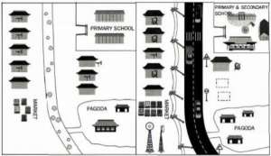
The maps below shows the town of Lynnfield in 1936 and then later in 2007.
Summarise the information by selecting and reporting the main features, and make comparisons where relevant.
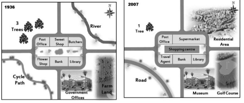
The maps detail changes to a town called Lynnfield between 1936 and 2007. Looking from an overall perspective, it is readily apparent that the town became more residential, commercial, and accessible at the expense of natural land, agriculture and smaller shops.
In 1936, to the northwest and northeast of the town were several trees and a river surrounded by untouched land. By 2007, the number of trees had declined and the land around the river became a residential area. To the southwest of the town, a cycling path was turned into a road for cars and on the opposite side of the map a museum and golf course replaced government offices and farm land.
In terms of the center of the town itself, there was a post office, sweet shop and butcher’s in a single row with a lane separating those businesses from the flower shop, bank and library. In 2007, only the bank (slightly expanded in size), library, and post office remained the same. The flower shop had by then been removed in favor of a travel agent, there was a shopping center in the previously unoccupied space between businesses, and the sweet shop and butcher’s were combined and transformed into a large supermarket.
Analysis
1. The maps detail changes to a town called Lynnfield between 1936 and 2007. 2. Looking from an overall perspective, it is readily apparent that the town became more residential, commercial, and accessible at the expense of natural land, agriculture and smaller shops.
- Paraphrase the overall essay topic.
- Write a general over for the map. Include the major changes and group them generally.
1. In 1936, to the northwest and northeast of the town were several trees and a river surrounded by untouched land. 2. By 2007, the number of trees had declined and the land around the river became a residential area. 3. To the southwest of the town, a cycling path was turned into a road for cars and on the opposite side of the map a museum and golf course replaced government offices and farm land.
- Begin to describe the changes.
- Be sure to compare as much as possible.
- In this one I separated inside and outside the town itself.
1. In terms of the center of the town itself, there was a post office, sweet shop and butcher’s in a single row with a lane separating those businesses from the flower shop, bank and library. 2. In 2007, only the bank (slightly expanded in size), library, and post office remained the same. 3. The flower shop had by then been removed in favor of a travel agent, there was a shopping center in the previously unoccupied space between businesses, and the sweet shop and butcher’s were combined and transformed into a large supermarket.
- Switch to another part of the map.
- Don’t include any opinion and don’t forget any areas.
- Nothing should be left out!
Vocabulary
What do the words in bold below mean? Take some notes on a piece of paper to aid your memory:
detail show
Looking from an overall perspective, it is readily apparent that overall
residential houses, apartments
commercial businesses
accessible can be travelled to easily
expense interest
natural land nature
agriculture farming
smaller shops local businesses
northwest top left
northeast top right
several lots of
surrounded by around
untouched land nature with no developments
declined decreased
to the southwest of the town in the lower left part
cycling path where bikes ride
on the opposite side reversed part
replaced taken the place of
in terms of considering
butcher’s place to buy meat
single row one line
lane separating space keeping apart
slightly expanded in size got a little bigger
remain the same unchanged
removed in favor of taken away so that
previously unoccupied space place where nothing was there before
combined added together
transformed changed
Answers
Try to write down or think of an antonym/opposite word for further practice:
The maps detail changes to a town called Lynnfield between 1936 and 2007. Looking from an overall perspective, it is readily apparent that the town became more residential, commercial, and accessible at the expense of natural land, agriculture and smaller shops.
In 1936, to the northwest and northeast of the town were several trees and a river surrounded by untouched land. By 2007, the number of trees had declined and the land around the river became a residential area. To the southwest of the town, a cycling path was turned into a road for cars and on the opposite side of the map a museum and golf course replaced government offices and farm land.
In terms of the center of the town itself, there was a post office, sweet shop and butcher’s in a single row with a lane separating those businesses from the flower shop, bank and library. In 2007, only the bank (slightly expanded in size), library, and post office remained the same. The flower shop had by then been removed in favor of a travel agent, there was a shopping center in the previously unoccupied space between businesses, and the sweet shop and butcher’s were combined and transformed into a large supermarket.
Pronunciation
Practice saying the words below using this tip with Google voice dictation:
ˈdiːteɪl
ˈlʊkɪŋ frɒm ən ˈəʊvərɔːl pəˈspɛktɪv, ɪt ɪz ˈrɛdɪli əˈpærənt ðæt
ˌrɛzɪˈdɛnʃəl
kəˈmɜːʃəl
əkˈsɛsəbl
ɪksˈpɛns
ˈnæʧrəl lænd
ˈægrɪkʌlʧə
ˈsmɔːlə ʃɒps
ˌnɔːθˈwɛst
ˌnɔːθˈiːst
ˈsɛvrəl
səˈraʊndɪd baɪ
ʌnˈtʌʧt lænd
dɪˈklaɪnd
tuː ðə ˌsaʊθˈwɛst ɒv ðə taʊn
ˈsaɪklɪŋ pɑːθ
ɒn ði ˈɒpəzɪt saɪd
rɪˈpleɪst
ɪn tɜːmz ɒv
ˈbʊʧəz
ˈsɪŋgl rəʊ
leɪn ˈsɛpəreɪtɪŋ
ˈslaɪtli ɪksˈpændɪd ɪn saɪz
rɪˈmeɪn ðə seɪm
rɪˈmuːvd ɪn ˈfeɪvər ɒv
ˈpriːviəsli ʌnˈɒkjʊpaɪd speɪs
kəmˈbaɪnd
trænsˈfɔːmd
Vocabulary Practice
Remember and fill in the blanks. Note it on a piece of paper so you can remember better:
The maps d_______l changes to a town called Lynnfield between 1936 and 2007. L_________________________________________________t the town became more r_____________l, c_____________l, and a___________e at the e________e of n_________d, a__________e and s__________s.
In 1936, to the n___________t and n___________t of the town were s__________l trees and a river s_______________y u___________________d. By 2007, the number of trees had d_________d and the land around the river became a residential area. T__________________________n, a c____________h was turned into a road for cars and o__________________e of the map a museum and golf course r_________d government offices and farm land.
I____________f the center of the town itself, there was a post office, sweet shop and b__________s in a s___________w with a l________________g those businesses from the flower shop, bank and library. In 2007, only the bank (s___________________________e), library, and post office r_____________e. The flower shop had by then been r_____________________f a travel agent, there was a shopping center in the p_________________________e between businesses, and the sweet shop and butcher’s were c__________d and t_____________d into a large supermarket.
Listening Practice
Listen to the related topic below and practice with these activities
https://www.youtube.com/watch?v=PST3FzzU7-k
Reading Practice
Read more and use these ideas to practice:
Speaking Practice
Practice with the following related questions from the real IELTS speaking exam:
Where you Live
My sample speaking for these questions is here.
- Where do you live at the moment?
- What do you like about your neighborhood?
- Are there any parks where you live?
Writing Practice
Practice with the related map below and then check with my sample answer:
https://howtodoielts.com/ielts-essay-task-1-science-park-map/


Brilliant stuff
Thank you!
Hello! Am new hetr
Nice to meet you Tinamee!
U used wrong tens in last paragraph it is not about present so why u used has been and is
The tenses are correct, Anmol.
Present perfect can be used for an event that happened in the past at an unclear time and is true not and present simple for how it is now.
Is that clearer?
IELTS
For sure, Naresh!
hey dave, my teacher told me to write down the most noteworthy changes in the maps to my overall part. However, you choose to write your comments in this part(for example,you wrote above that the town became more residential, commercial,...) I wonder which the best option was.
It is best in the overview for a map to group/describe the changes.
If you just write the biggest changes, you are at risk of an automatic band 5 for task reponse…
Is that clear, Tran?
The illustration presents the difference of Lynnfield in 1936 and 2007.
Some of the buildings in the center area have changed, and a new shopping center has been built. The edge of town is further developed, where a residential area and a wide road appear.
In the central area, the post office, bank, and library have stayed the same for 71 years. A new shopping center shows up in the middle of the urban. The sweet shop and butchers are combined as a supermarket. While a travel agent takes place in the flower shop.
When looking at the edge of Lynnfield, a huge residential area is conducted around the river. Many facilities are different, where government offices and farm land in 1936 are applied as museum and golf course in 2007. Moreover, the cycle path is rebuilt as a wide road.
Good, Gakki!
Nice accurate grammar at times – you can’t start a sentence with ‘while’ though…
Good, Gakki!
‘and a wide road now in existence’ – careful with the accuracy of verb forms at times!
The graphs detail about the population trends in urban and rural areas along with the age distribution throughout out the years 1950 to 2040. Looking from an overall perspective, it is readily apparent that urban population has gradually increased along with the significant spike of the 15 to 65 age group. Giving the idea of greater urbanization due to the surge in people of ages 15 to 65.
Breaking it down, the age group 15 to 65 hiked from 6% in 1950 to 35% in 2040 along with fluctuations throughout the years. Following this trend, the urban population upsurged from a percentage of 6 to 38 with slight dips from 1950 to 2040.
In contrast, the age distribution, over 65, has increased but at a considerably low rate from 3% to 5% with a drop to 2% at the year 1960. Hence leading to an unnoticeable growth in the rural population from approximately 4% to 5%.
Lastly, children under the age of 15 had the same trend as adults over 65 rather than the slight increase in the 60’s. The total population has also flourished to 45% in 2040 from 11% in the 50’s as it’s a combination of both the rural and urban population.
Great, Shaima!
Really nice overview and your grammar and vocabulary is very accurate.
Some collocations a bit off though like ‘unnoticeable growth’.
The map describes the changes in the structure of the town of Lynnfield between 1936 and 2007. Looking from an overall perspective, it is readily apparent that both the city centre and the outskirts of the city has developed dramatically.
In comparison to 1936, when the hub of the city, confined in the middle of the map, was composed by a pedestrian zone and several essential local stores, the shopping centre took a place of the hub instead during the last seven decades. Also, local stores as the butchers and the candy shop were united and replaced by a supermarket. Other than that, the main social services buildings including the library, the bank and the post office remained untouched during the earlier mentioned period.
Whether in the earlier times of the city history, the surrounding areas had mostly a natural character, reaching 2007 these areas were already largely used as residential areas and tourist attractions as a museum or a golf course. Over the period of a time between 1936 and 2007, in the south-eastern neighbourhood, a museum has replaced the old government offices and farmland has been turned into a golf course. In addition, residential houses have been constructed on both sides of the river situated on the north-eastern edge of the city. Finally, the western part of the city mostly kept its natural character, except the road replacing the former path for cyclists and reduction of the tree growth.
Good work, Zu!
Some of it borders on opinion and speculation – don’t speculate!