IELTS Essay: Map of a City in 1950
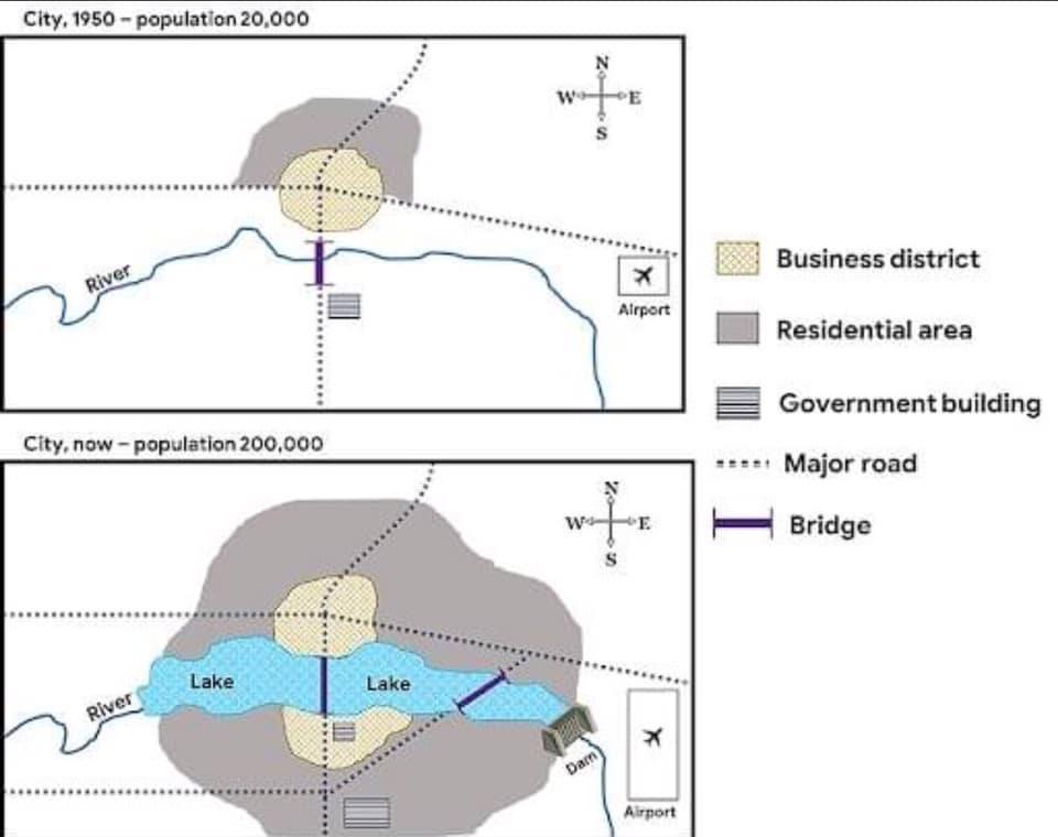
The map describes changes to a city since 1950. Looking from an overall perspective, it is readily apparent that the city has expanded to become considerably more residential and accessible, with the notable additions of a long lake and nearby business district.
In 1950, the town’s population was 20,000 and it has increased tenfold to 200,000. Previously, there was a limited area for homes, all to the north of the major road running east to west. At present, the residential area has greatly grown in all directions and there are now additional major roads in the southern half of the city.
Moreover, the narrow river running through the town has been dammed to create a large lake that stretches from the western to eastern edge of the residential area. The business district which was confined to the center of the map is now larger and includes the northern and southern shores of the lake. The bridge over the river is now over the lake and there is another bridge near the dam in the east. Finally, there is presently a second government building to the south and the airport located to the east has more than doubled in size.
Analysis
1. The map describes changes to a city since 1950. 2. Looking from an overall perspective, it is readily apparent that the city has expanded to become considerably more residential and accessible, with the notable additions of a long lake and nearby business district.
- Paraphrase what the map shows.
- Write a clear overview summarising the major changes.
1. In 1950, the town’s population was 20,000 and it has increased tenfold to 200,000. 2. Previously, there was a limited area for homes, all to the north of the major road running east to west. 3. At present, the residential area has greatly grown in all directions and there are now additional major roads in the southern half of the city.
- Begin writing about the details of the map.
- Compare to other areas on the map.
- After a few sentences, start a new paragraph.
1. Moreover, the narrow river running through the town has been dammed to create a large lake that stretches from the western to eastern edge of the residential area. 2. The business district which was confined to the center of the map is now larger and includes the northern and southern shores of the lake. 3. The bridge over the river is now over the lake and there is another bridge near the dam in the east. 4. Finally, there is presently a second government building to the south and the airport located to the east has more than doubled in size.
- Write about the rest of the map- include everything!
- Try to paraphrase some of the words from the map as well.
- There is a lot in this one so you might have to write a little longer.
- Be sure you mention what has not changed much too.
Vocabulary
The map describes changes to a city since 1950. Looking from an overall perspective, it is readily apparent that the city has expanded to become considerably more residential and accessible, with the notable additions of a long lake and nearby business district.
In 1950, the town’s population was 20,000 and it has increased tenfold to 200,000. Previously, there was a limited area for homes, all to the north of the major road running east to west. At present, the residential area has greatly grown in all directions and there are now additional major roads in the southern half of the city.
Moreover, the narrow river running through the town has been dammed to create a large lake that stretches from the western to eastern edge of the residential area. The business district which was confined to the center of the map is now larger and includes the northern and southern shores of the lake. The bridge over the river is now over the lake and there is another bridge near the dam in the east. Finally, there is presently a second government building to the south and the airport located to the east has more than doubled in size.
Answers
describes shows
Looking from an overall perspective, it is readily apparent that overall
expanded grown
considerably more residential many more houses
accessible can be reached
notable additions important new areas
lake large body of water, pond
nearby business district place for offices, work around there
tenfold 10x, 1000%, ten times as large
previously before
limited area not a large place
to the north of located north of
major big
running east to west going from the right to left
at present right now
residential where people live
greatly grown increased a lot
all directions every way
additional more
southern half of the city lower part
moreover additionally
narrow not wide
dammed a blockage in the river to build up water
stretches goes all the way
edge outer point of
confined kept within certain bounds
shores beaches, edges
bridge road over water or land
finally in the end
presently right now
located to the east to the right side
doubled 2x, 200%
Pronunciation
Practice saying the words below using this tip with Google voice dictation:
dɪsˈkraɪbz
ˈlʊkɪŋ frɒm ən ˈəʊvərɔːl pəˈspɛktɪv, ɪt ɪz ˈrɛdɪli əˈpærənt ðæt
ɪksˈpændɪd
kənˈsɪdərəbli mɔː ˌrɛzɪˈdɛnʃəl
əkˈsɛsəbl
ˈnəʊtəbl əˈdɪʃ(ə)nz
leɪk
ˈnɪəbaɪ ˈbɪznɪs ˈdɪstrɪkt
ˈtenfəʊld
ˈpriːviəsli
ˈlɪmɪtɪd ˈeərɪə
tuː ðə nɔːθ ɒv
ˈmeɪʤə
ˈrʌnɪŋ iːst tuː wɛst
æt ˈprɛznt
ˌrɛzɪˈdɛnʃəl
ˈgreɪtli grəʊn
ɔːl dɪˈrɛkʃənz
əˈdɪʃənl
ˈsʌðən hɑːf ɒv ðə ˈsɪti
mɔːˈrəʊvə
ˈnærəʊ
ˈdæmid
ˈstrɛʧɪz
ɛʤ
kənˈfaɪnd
ʃɔːz
brɪʤ
ˈfaɪnəli
ˈprɛzntli
ləʊˈkeɪtɪd tuː ði iːst
ˈdʌbld
Vocabulary Practice
Remember and fill in the blanks:
The map d___________s changes to a city since 1950. L______________________________________________________t the city has e______________d to become c___________________________l and a______________e, with the n___________________s of a long l_____e and n_______________________t.
In 1950, the town’s population was 20,000 and it has increased t___________d to 200,000. P______________y, there was a l______________a for homes, all t______________f the m_____r road r__________________t. A_____________t, the r_________________l area has g____________n in a_____________s and there are now a_____________l major roads in the s_______________________y.
M_______________r, the n_________w river running through the town has been d________d to create a large lake that s___________s from the western to eastern e____e of the residential area. The business district which was c_________d to the center of the map is now larger and includes the northern and southern s________s of the lake. The b_____e over the river is now over the lake and there is another bridge near the dam in the east. F________y, there is p___________y a second government building to the south and the airport l_________________t has more than d__________d in size.
Listening Practice
Listen to the related topic below and practice with these activities:
Reading Practice
Read more and use these ideas to practice:
https://www.wired.com/2015/09/design-issue-future-of-cities/
Speaking Practice
Practice with the following related questions from the real IELTS speaking exam:
Cities
- Have you ever lived in a city?
- What do you enjoy most about living in the city?
- Which city would you like to live in in the future?
- Do most people in your country live in cities?
Writing Practice
Practice with the related process below and then check with my sample answer:


0 Comments