This is an IELTS writing task 1 sample answer essay on the topic of a map of the town of Willington.
Please consider supporting my efforts to creative high quality IELTS materials for students around the world by signing up for my Patreon (and so you won’t miss out on any of my exclusive IELTS Ebooks)!
Dave
IELTS Task 1: Town of Willington
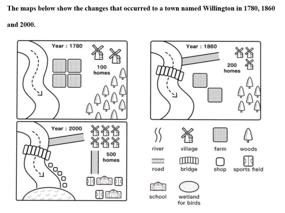
The map details changes that occurred in the town of Willington in the years 1780, 1860, and 2000. Looking from an overall perspective, it is readily apparent that the village became more residential and commercial, including new homes, access roads, a bridge, shops, and areas for recreation and sports at the expense of natural forests and farms. Only the river remained unchanged.
In 1780, there were only 100 homes in Willington and a considerable region to the east and south was occupied by farms and woods. The river ran from north to south alongside the town, a feature that was unaltered by 2000. By 1860, some farms and forest had been removed to allow for a road leading from the river to a residential area that had doubled in size (200 homes) in the northeast. There was also the appearance of a bridge over the river.
In 2000, the number of homes rose to 500 and the farms and forests were entirely cleared. This enabled the construction of two schools, 3 sports fields and numerous shops lining the southern side of the river. The final addition was a large lake at the south end of the river.
Analysis
1. The map details changes that occurred in the town of Willington in the years 1780, 1860, and 2000. 2. Looking from an overall perspective, it is readily apparent that the village became more residential and commercial, including new homes, access roads, a bridge, shops, and areas for recreation and sports at the expense of natural forests and farms. 3. Only the river remained unchanged.
- Paraphrase what the map shows.
- Write a clear overview summarising the major groups.
- You might need a 3rd sentence for your overview.
1. In 1780, there were only 100 homes in Willington and a considerable region to the east and south was occupied by farms and woods. 2. The river ran from north to south alongside the town, a feature that was unaltered by 2000. 3. By 1860, some farms and forest had been removed to allow for a road leading from the river to a residential area that had doubled in size (200 homes) in the northeast. 4. There was also the appearance of a bridge over the river.
- Begin writing about the details of the map.
- Transition between parts of the map logically.
- Include every area on the map.
1. In 2000, the number of homes rose to 500 and the farms and forests were entirely cleared. 2. This enabled the construction of two schools, 3 sports fields and numerous shops lining the southern side of the river. 3. The final addition was a large lake at the south end of the river.
- Write about the rest of the map – include everything!
- Try to paraphrase some of the words from the map as well.
- Add in the last part of the map.
Vocabulary
What do the words in bold below mean? Take some notes on a piece of paper to aid your memory:
The map details changes that occurred in the town of Willington in the years 1780, 1860, and 2000. Looking from an overall perspective, it is readily apparent that the village became more residential and commercial, including new homes, access roads, a bridge, shops, and areas for recreation and sports at the expense of natural forests and farms. Only the river remained unchanged.
In 1780, there were only 100 homes in Willington and a considerable region to the east and south was occupied by farms and woods. The river ran from north to south alongside the town, a feature that was unaltered by 2000. By 1860, some farms and forestry had been removed to allow for a road leading from the river to a residential area that had doubled in size (200 homes) in the northeast. There was also the appearance of a bridge over the river.
In 2000, the number of homes rose to 500 and the farms and forests were entirely cleared. This enabled the construction of two schools, 3 sports fields and numerous shops lining the southern side of the river. The final addition was a large lake at the south end of the river.
Answers
Try practicing with the vocabulary below by writing an antonym/opposite word on a piece of paper (or just thinking of one):
details shows
occurred happened
Looking from an overall perspective, it is readily apparent that overall
village small town
residential place where people can live, houses/homes
commercial related to business
access roads ways to get into a place
bridge a raised street over water or land
areas for recreation places to chill out
at the expense of natural forests removing the woods
farms agricultural areas
remained unchanged stay unaltered
considerable region big area
occupied by taking the place of
woods forests
ran from north to south alongside the town going from the top to the bottom next to the village
feature notable part
unaltered unchanged
forest woods, trees
removed to allow for a taken away so that
leading from the river to a residential area going from a stream to the housing district
doubled 200% increase
appearance how it looks outside
rose to increased to
entirely cleared gotten rid of completely
enabled allowed for
construction building of
lining alongside
southern side of the river bottom part of the water
The final addition was the last area added was
south end bottom part
Pronunciation
Practice saying the words below using this tip with Google voice dictation:
ˈdiːteɪlz
əˈkɜːd
ˈlʊkɪŋ frɒm ən ˈəʊvərɔːl pəˈspɛktɪv, ɪt ɪz ˈrɛdɪli əˈpærənt ðæt
ˈvɪlɪʤ
ˌrɛzɪˈdɛnʃəl
kəˈmɜːʃəl
ˈæksɛs rəʊdz
brɪʤ
ˈeərɪəz fɔː ˌriːkrɪˈeɪʃən
æt ði ɪksˈpɛns ɒv ˈnæʧrəl ˈfɒrɪsts
fɑːmz
rɪˈmeɪnd ʌnˈʧeɪnʤd
kənˈsɪdərəbl ˈriːʤən
ˈɒkjʊpaɪd baɪ
wʊdz
ræn frɒm nɔːθ tuː saʊθ əˈlɒŋˈsaɪd ðə taʊn
ˈfiːʧə
ʌnˈɔːltəd
ˈfɒrɪst
rɪˈmuːvd tuː əˈlaʊ fɔːr eɪ
ˈliːdɪŋ frɒm ðə ˈrɪvə tuː ə ˌrɛzɪˈdɛnʃəl ˈeərɪə
ˈdʌbld
əˈpɪərəns
rəʊz tuː
ɪnˈtaɪəli klɪəd
ɪˈneɪbld
kənˈstrʌkʃən
ˈlaɪnɪŋ
ˈsʌðən saɪd ɒv ðə ˈrɪvə
ðə ˈfaɪnl əˈdɪʃ(ə)n wɒz
saʊθ ɛnd
Vocabulary Practice
Remember and fill in the blanks:
The map d_______s changes that o________d in the town of Willington in the years 1780, 1860, and 2000. L_____________________________________________________t the v________e became more r_________l and c____________l, including new homes, a___________s, a b_______e, shops, and a__________________n and sports a___________________________s and f_______s. Only the river r______________________d.
In 1780, there were only 100 homes in Willington and a c_______________n to the east and south was o_____________y farms and w_____s. The river r______________________________________n, a f_________e that was u_________d by 2000. By 1860, some farms and f________y had been r__________________a road l___________________________________a that had d______d in size (200 homes) in the northeast. There was also the a_________e of a bridge over the river.
In 2000, the number of homes r______o 500 and the farms and forests were e______________d. This e________d the c_______________n of two schools, 3 sports fields and numerous shops l______g the s_____________________r. T___________________________s a large lake at the s_______d of the river.
Listening Practice
Listen to the related topic below and practice with these activities:
Reading Practice
Read more and use these ideas to practice:
https://www.thecanadianencyclopedia.ca/en/article/urbanization
Speaking Practice
Practice with the following related questions from the real IELTS speaking exam:
Where you Live
- Where is your hometown?
- Would you like to live there in the future?
- What don’t you like about your home?
Writing Practice
Practice with the related process below and then check with my sample answer:


Super ❤️
Thanks, Anar!
Hey¡ Are you practicing for the IELTS exam? I need a partner to practice my speaking. I can help you as well.
The diagrams illustrate the developments which had been made throughout the years 1780, 1860, and 2000.
Overall, we can see that the town had undergone a drastic change from a rural area to an urbanized city. New buildings and amenities had been constructed, and the population increased since more homes were constructed over the 220-year period.
First and foremost, in 1780, Willington town had 4 farms next to the river. In the northeastern corner, there used to be two villages and one hundred homes. At the bottom right of the map, there was a forest with lots of trees. By 1860, a few changes had been made, a new village had been constructed in the top right corner, and the number of homes doubled. However, the farms had been demolished and only two remained. Similarly, the trees had been cut down. To get and cross the river a road and a bridge had been built.
Furthermore, the biggest changes had occurred by 2000. The number of villages doubled and the number of homes almost tripled. All of the remaining farms had been demolished, as well as the trees, to make way for two schools and three sports fields. A new road had been erected to get to the new constructions. Moreover, five shops were built along the north side of the river. Finally, at the end of the river, a wetland for birds had been built.
Awesome work – keep it up!
Perfect answer
The maps indicate the developments that occurred in Willington during 1780, 1860 and 2000.
Overall, it can be viewed that the plan is to take over an underdeveloped area and form it into an urban city by excreting farms and trees and instead forming educational facilities and accommodations for the new residents.
In 1780, the town included four sectors of farm just beside the river. There has been a minimum process of deforestation conducted due to which 2 villages had been established, enabling 100 housing units on the eastern side of Willington.
By the year of 1860, half of the farming division had been demolished. Moreover, this case was applied to the trees; as they had been significantly reduced as well. Because of this demolishments, it had not only made way for an additional village, but had also led to a construction of a new road present on the northern area of the city. In addition, on the left side of the farming area, there had been a bridge formed for the citizens in order for them to cross the river easily..
Lastly, in the year 2000, the natural places, trees and farming, had been completely eliminated from Willington town. It had been completely developed into an urban area with more than double the number of homes in 1860. For children’s learning, three sports fields and two schools had been developed. Moreover, an extra road had been built that linked the residents straight to the children’s facilities. For adults, there are five stores besides the river, which starts at the side of the bridge and ends at a wetland area for birds.
The maps illustrate how a town name Willington had developed over three different time periods (1780, 1860 and 2000). Generally, there had been exponentially changes in residential area, transportation and facilities at the east of the river which remained unchanged.
In 1780, Willington town had only 100 homes with many farms and woods, as well as the river flowing from the north to the south. By 1860, the town became more improvement with a road linked between the river and housings that had doubled in size at 200 homes, while the amount of farms and woods had been reduced. A bridge, moreover, had been built to connect each side of the river.
There were a significant growth in its facilities such as schools, more shops and sports fields, in 2000. Another road had been constructed for transportation from schools and sports area to residential places which obviously rose to 500 homes. It can be clearly seen that both farms and woods had been removed completely. In addition, there was a wetland for birds at the one end of the river.
To summarize, the town was substantially flourished with several housings, transportation and other facilities in 2000.
The illustrations presented describe how 1780, 1860 and 2000 changed the town and what transformations took place. Looking from an overall perspective, it is readily apparent that the town has become much more comfortable to live in owing to the amenities that have appeared in it. It has also become easier to move around it due to the new roads and the bridge. However, the town has lost all its greenness.
The first road was built in 1860. It connected the side of the river with the homes, which had doubled by that time in comparison to 1780. Additionally, a bridge was constructed connecting the sides of the river.
By 2000 all farms and woods had been eliminated. Instead of them 2 schools with 3 sports fields and several shops were built. The number of homes increased to 500 and a new road connecting them to schools appeared. It is important to mention the wetland for birds which was also built that year.
They didn’t mention compass in the map, then how can we write north, south, east,west?
Please reply me back with a solution to the above question.
To be safe, you can right bottom/left etc – but generally it should be fine to use the directions even if there is no compass.
It might come down to the individual examiner though.
Sorry it’s not clearer than that, Kedarnath!